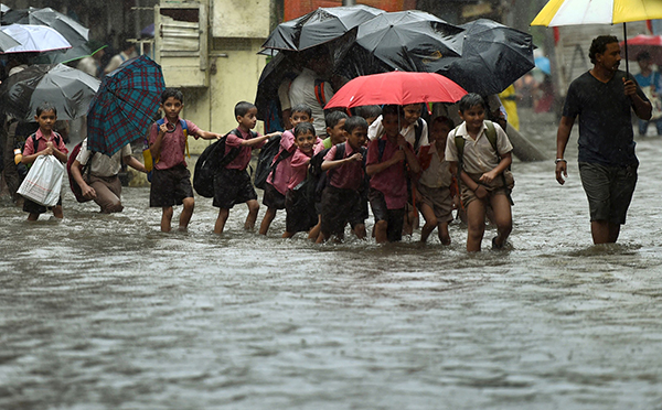
Indian school children walk along a flooded street during heavy rain showers in Mumbai on Aug 5. — AFP Photo
THE pendulum is swinging from El Nino to La Nina. The 2015 to 2016 El Nino event will go down in meteorological records as this year is expected to be the hottest since records began. Vietnam, a major exporter of rice, suffered its worst drought for over a century.
On May 19, the African inland state of Niger recorded its highest ever temperature at 49 degrees Celsius and on the same day India set a new national record of 51 degrees Celsius.
Nine other nations recorded new May highs, often with disastrous effects on their economies. Southeast Asia has experienced a heatwave and drought leading to some deaths, whilst violent storms have hit many western Pacific countries and their offshore islands and part of Alberta province in Canada has been swept by wildfires.
The El Nino-Southern Oscillation (Enso)
During ‘normal’ climatic conditions, monsoon times can be predicted and rain will fall with the Southwest Monsoon sweeping over West Kalimantan, Sarawak and north to Sabah. Later in the year, the Northeast hits Sabah and East Kalimantan. This is known as the Southern Oscillation, which simply is a gigantic seesaw-like effect of high and low pressure systems between the Pacific and Indian oceans. High pressure in the Pacific is matched by very low pressure over India and vice versa.
An El Nino episode disrupts this system, for it is one huge global atmospheric and oceanic event leading to an upsurge in temperatures of the tropical Pacific Ocean. Vast quantities of energy are released into the atmosphere thus pushing up global temperatures.
In mid-June this year, Java suffered severe flooding and resultant landslides killing over 50 people and hundreds of homes were engulfed by rock-falls and mudflows. Record national temperatures were recorded in the same month in Cambodia, Laos and in Singapore. In contrast, at the same time, Niger’s north western desert received a year’s worth of rainfall (7.5 centimetres) in just two hours, resulting surprisingly in the deaths of only two people but thousands of camels and livestock perished.
In the past El Nino (the boy child) events have been followed by La Nina (the girl child) episodes but some consolation may be drawn from the fact that a strong El Nino does not necessarily lead to an equally powerful La Nina.
What causes the La Nina phenomenon?
As implied earlier, atmospheric conditions are directly related to sea surface temperatures. The oceanic/atmospheric systems are part of a major global system of heat and cold transfer from the tropics to and from the poles. Our seas hold vast quantities of heat. The uppermost three metres of our oceans hold more heat than that in the entire atmosphere and manage to transfer this heat to the air above by reflection, radiation and conduction.
How do these processes trigger cooler than normal subsurface temperatures in the central and eastern Pacific Ocean in a La Nina episode? Westerly moving air and ocean currents pull water away from west coast of South America, thus allowing an upwelling of cold water there from the lower depths of the ocean. This has a beneficial effect as far as the Peruvian and Chilean fishermen are concerned, for nutrient rich material is dragged upwards to the surface, allowing rapid plankton growth leading in turn to a feeding frenzy for fish. The local anchovy fishing economy receives an enormous boost.
An increase in sea temperature on the western side of the Pacific Ocean, in the eastern and south eastern Asian countries, allows the transfer of more energy into the atmosphere, resulting in the greater frequency of thunderstorms.
With the warmer Southwest Trade winds meeting the cooler, denser Northeast Trade winds an undercutting of the warmer air lifts it aloft to cool and condense. This partially explains the higher than normal rainfall experienced in Borneo during the last La Nina event in 2011.
La Nina this year?
The national meteorological offices of Australia, United Kingdom and the USA are all confident that a La Nina event will occur this year. The UK’s Meteorological Office’s Hadley Centre, equipped with the most sophisticated meteorological computers in the world, is more than 80 per cent confident that the La Nina phenomenon will develop in summer and peak in the northern hemisphere’s winter months. The US Meteorological Service predicts eight North Atlantic hurricanes (twice as many as last year) to strike land between June and November this year.
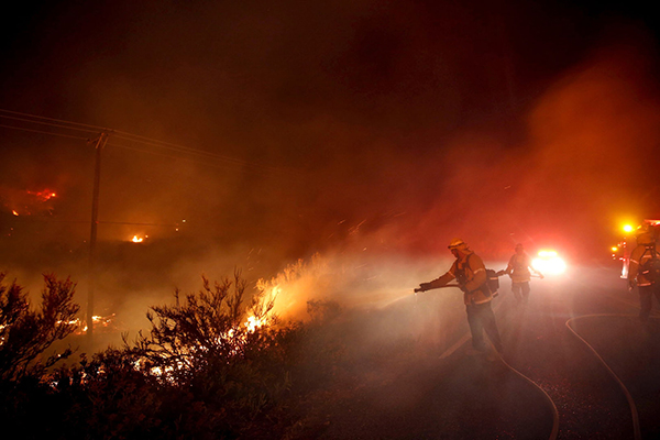
Firefighters control the fire roadside during the Pilot Fire near Silverwood Lake in San Bernardino county near Hesperia, California, US on Aug 7. — Reuters photo
Have our memories faded?
Unless they have had a dramatic effect on our personal lives, it is perhaps a good thing that we forget past weather conditions and focus on present and future weather predictions.
In 2011, we saw the strongest La Nina event over the previous 50 years. Southeast Australia suffered from an invasion of locusts while Queensland recorded a record-breaking cotton harvest. Southeast Asia was swamped with rain and in only one week in the Philippines incessant, torrential rainfall caused flooding and subsequent landslides, forcing 33,000 people to evacuate their homes. Bintulu, Kuching, Miri and Sri Aman recorded higher than average rainfall in many months of that year.
The west coast states of the US were battered by violent storms. Los Angeles recorded a new December rainfall record of 23 centimetres, with numerous landslides in that region of California. In the same state the Sierra Nevada Mountains received record snowfalls, boosting ski resort-incomes. In the deserts of Arizona and New Mexico higher than average monthly rain fell and snow even occurred in Phoenix that New Year’s Eve.
Preparations
If we base our weather forecasts on the previous La Nina event, then most of Borneo can expect a very wet weather period between December and February. February 2011 saw a peak in La Nina in Borneo. Elsewhere, in northwest Europe hurricane-force winds are likely and in the USA the forecasters suggest a 50 per cent chance of hurricanes. It is anticipated that the UK will experience a mild and wet end to the winter months in early 2017 with likely flooding.
El Nino and La Nina episodes are not uncommon. Archaeological evidence suggests that these have been occurring for at least 15,000 years but it was only in the mid-1970s that their worldwide and widespread impacts were recognised.
The global damage caused by such events amounts to very many billions of dollars and with inevitable death tolls. Recently these episodes have been intensified by global warming and climate change.
Let us see, wherever we live, how this year’s weather will unfold but we need to be fully prepared with all our emergency services fully trained to cope with and anticipate potential local disasters. Sadly ‘the girl child’, whilst appearing mermaid-like, carries a vicious sting in her tail.